Chasing the Fire, Part 2 - Planning
How do you go see a volcanic eruption?
Published on Wednesday, 16 August 2023. Revision 2.
Contents
Chasing the Fire, Part 2
How do you go see a volcano?
Published on Tuesday, 8 August 2023.
The spring and early summer of 2023 was quite busy for me.
I was working on multiple projects at work, multiple photography
assignments, and I spent seven weeks in a marathon sprint to
finish the Friars Hole Cave System map for the 2023 NSS
Convention in late-June. For two or three months I was working
roughly 60-80 hours per week. There were three weeks in July
that I was keeping open and clear just so I had time to spend
at home doing home projects and decompressing.
Reykjanes Reawakens
I was one week into this break when southwest Iceland began
shaking. An earthquake swarm began on July 4 which rattled the cities of
Reykjavik and Grindavik. A couple more days of data collecting
made it official: magma was on the move under the Reykjanes
Peninsula for the third time in three years.
At first, I ignored the earliest warning signs. I was in a bit of a recovery period and earthquake swarms happen routinely in active volcanic zones without ever having an eruption. The Reykjanes Peninsula sits over top of the Western Volcano Zone, a section of the rifting zones which split through Iceland. Magma routinely moves under this part of the island by forcing itself upwards into narrow, vertical, intrusions called dykes. As the magma rises the ground shakes, the surface begins to deform, and when the magma gets very close the escaping gases begin to become detectable. Frequently, however, the magma cools off and stops it’s upward motion without ever reaching the surface. This is a very common occurrence and is what makes it so hard to predict when volcanoes will erupt. For every intrusion that breaks the surface there may be dozens, or hundreds, of intrusions that never break through.
At first, I ignored the earliest warning signs. I was in a bit of a recovery period and earthquake swarms happen routinely in active volcanic zones without ever having an eruption. The Reykjanes Peninsula sits over top of the Western Volcano Zone, a section of the rifting zones which split through Iceland. Magma routinely moves under this part of the island by forcing itself upwards into narrow, vertical, intrusions called dykes. As the magma rises the ground shakes, the surface begins to deform, and when the magma gets very close the escaping gases begin to become detectable. Frequently, however, the magma cools off and stops it’s upward motion without ever reaching the surface. This is a very common occurrence and is what makes it so hard to predict when volcanoes will erupt. For every intrusion that breaks the surface there may be dozens, or hundreds, of intrusions that never break through.
A volcano can shake and rattle for weeks, it can bulge and
deform the surface, and it can give off surprisingly large
amounts of gas… and then nothing. Dropping everything and
flying off to a shaking volcano is practically pointless
unless its your job or you have a lot of expendable resources.
In Reykjanes, for example, a similar earthquake swarm happened
just a few months prior. Out of caution the Icelandic Police
set up a hazard zone in the northern part of Fagradalsfjall
where the earthquakes were centered. The official hazards
listed were landslides, earthquakes, and the possibility of a
volcanic eruption.
Escalation, Deformation, and Anticipation
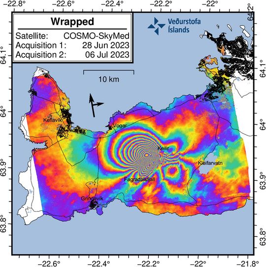
The situation had escalated by July 6. Not only were earthquakes
becoming more frequent, they never really stopped. Magma was now moving
more or less constantly, the result being that seismometers never really
settled down. This pattern is called tremor and it’s one of the
strongest signals that magma is moving. At the same time the peninsula
itself began to deform. Parts of the Reykjanes Peninsula had moved by
18 centimeters (7 inches) in just a week.[1] As the magma rises, the
locations of the earthquakes rise as well.
By July 10 the earthquakes
were so shallow that scientists could no longer pinpoint exactly where
they were. Magma was now less than 500 meters below the surface but no
one could tell exactly where it was and when. Earthquakes were now
strong enough to cause small-scale rockslides on the hills of
Fagradalsfjall.
An eruption was nearly certain. Afar TV on YouTube had already set up cameras in the region pre-emptively to try to catch the start of the eruption and locals had been camped out in the area. I was beginning to accept that I may have to kill my three week break and was starting to eyeball flights from Baltimore to Keflavik for the latter half of July and the second half of August.
Every morning I’d wake up and check the news, check YouTube, and of course check social media. All provided fairly rapid updates (once you waded through the hip-deep bullshit that exists on social media platforms). The morning of July 11 I woke up and checked the news – nothing new. The ground was still shaking and everyone was still waiting. I had a running live feed of Reykjanes on my external monitor.
I got up and refilled my coffee, when I returned the sunny blue skies over Iceland were replaced by a very, very, large plume of thick smoke. I did a double take and began checking local news sources – sure enough the eruption had begun.
Eruption
The start of an effusive eruption is quite dramatic. The area
north of Fagradalsfjall is an open, flat, mossy plain. For
folks in the area the first sign that things were escalating
would have been changes in the character of earthquakes. The
rocking, swaying, motion of the previous earthquakes would
have changed to sharper, more abrupt, jolts. Instead of
somewhat random vibrations the new motion would have felt
less like general shaking and more like the ground was
being lifted up and out.
At 16:48 local time on July 10, a series of cracks and fissures over 200m long ripped open in the middle of the plains. White clouds of gas began to rise from the fissure, at first a loud hiss and then a gentle roar. The gases were so hot they began to ignite the moss around the fissures. Within seconds the gases gave way to sputtering bubbles of lava: the eruption was on. Within five minutes tens of thousands of square meters of ground was covered by fresh lava erupting from a line of fiery lava fountains nearly 100 feet tall.
This was happening without most people seeing it. The eruption began just out of view of the webcams, blocked by a hill called Litli-Hrutur (Icelandic for Little Ram). All we could see was huge clouds of smoke from burning moss. Our blindness was short lived; within minutes locals were livestreaming the eruption from the ground and from the air via drones. One person even caught the very start of a second fissure opening up just south of the first one.
Should I Stay Or Should I Go?
Across the island and across the world people began
moving towards the eruption, me included. This
time the eruption was happening at a time when I
had the resources to go. Unfortunately, I only
barely had the time. Hope and I would have to fly
out on a Friday night and return on the following
Sunday. We would only have 36 hours in Iceland.
Commitments, both financial and logistical, in the
very near future meant that if we did not go this
time, we may lose all chances for the next couple
of years.
I waffled and wavered. Do you really commit this much money, this many resources, to a one-time ace-in-the-hole chance?
After about two hours of deliberation, I bought plane tickets.
Well, I tried to buy plane tickets. The instant I tried to buy tickets on Play Air’s website, PNC Bank flagged my card for fraud. What ensued was an hour and half of begging PNC to release my card. By the time I convinced them that I actually was trying to buy plane tickets to Iceland the surge in demand caused the algorithms to jack the prices up. The $800 tickets jumped to nearly $2000. My chance came and went in less than an hour. I was pissed.
I was pissed, but I kept an eye on ticket prices. In two hours the dropped again, lower than they were before the eruption began. I pounced. Once again my credit card was flagged for fraud, this time I kept PNC on the phone until I paid for them. After four hours of ups and down we had tickets, and we were going.
Chaos
Ten days of agony ensued. I suddenly had a thousand questions
running through my head: how do we hike out to this thing?
Where is it erupting and what’s a good view point? Can we do
it in the 36 hours we’ve allotted? What gas masks should I get?
Of all the questions, one loomed large: How do I stay out of
the way?
I was not alone in this. Nearly 400,000 people went and watched the first eruption. The second eruption saw over 10,000 people in just the first day. This eruption was quickly becoming no different. Thousands of people flocked to the valley north of Fagradalsfjall to see the eruption. Thus begins the next part in this story.
Humans destroy everything they touch. You can’t change my mind. There is always a minority destroying it for the majority. I saw this in Yellowstone when I lived there, my most special places in that park are now off limits and patrolled on horseback by backcountry rangers. Being caught in those areas now carries the risk of thousands of dollars in fines, or even jail. Why? Because people went back there, went hot-potting (swimming in hot springs) and got injured. And in this good United States of America, that’s just a liability we can’t have. Iceland is noted for it’s hands-off policies. But all policies have limits.
In the first few days of the eruption thousands of tourists made their trek out to the volcano along the path published by local officials. There was one problem: the volcano erupted in the dry season for Iceland and promptly set thousands of acres of moss on fire. The smoke from these wildfires drifted south directly along the 10 km (6mi) path. Visitors, many of whom had next to no understanding of what they were doing, fought their way through 20km of wildfire smoke unprotected and went to the hospital with lung damage. In two days the police department closed off all access to the volcano, an action directly backwards to the Icelandic culture of allowing people to see natural events like this. I could accept failure for a number of reasons: the weather, the volcano stops erupting - or starts erupting too much – but I can not accept being stopped because of the actions of an ignorant and defiant minority. Their actions became the number one cause of stress over the next week.
ICE-SAR - The Heroes of This Story
My complaints about the behavior of these people are, inherently,
selfish. They are insignificant in comparison to the effects
their behavior had on local officials.
Icelandic Search and Rescue (ICE-SAR) is an entirely volunteer ran organization in Iceland that dedicates itself to ensuring the safety of locals and visitors throughout the island. Frequently they get deployed to foreign disasters and accidents to aid in recovery efforts. Domestically, they are primarily deployed in the winter – this volcano is an exception. When this volcano begins to erupt, ICE-SAR is on scene 24/7 from the time it starts until it ends. They are not paid for this work, they take time off from their paying jobs to do it. They are rewarded with obscenely stupid behavior.
The first day or two of the eruption saw the initial surge of magma quiet down significantly. The eruption began with nearly 50 cubic meters per second (gallons per second) being dumped into the fields. By the next morning that rate dropped to just 12 cubic meters per second (gallons per second). The line of erupting fissures consolidated down into just a handful of vents which began building a significant spatter cone around itself. Within hours people were climbing on the cone.
OK, what mental calculus makes you think that is remotely a good idea? The cone holds back thousands of gallons of lava which is well over 2000°F. It is inherently very unstable; the rock isn’t cooled entirely. Its not a solid mass, it’s a bunch of sticky clay-like partially molten matter that holds itself together by habit and spite. They collapse routinely, and anyone right next to it stands no chance of getting out of the way in time.
This behavior was not tolerated by ICE-SAR and the local police. Only two days after being reopened to access the area was closed again, this time because of the behavior of this minority. It reopened after a day, with the official viewpoint being quite far away – 4km. From that distance the view was quite limited. The volcano was a black pimple on the horizon with the occasional bursts of lava above the crater rim. Impressive at night, totally not worth the trip out during the daytime.
I’ve only touched on the behavior that was obnoxiously bad, I didn’t touch on the behavior that was still benignly bad. Tourists would attempt the 20km hike without proper gear: poor footwear, no water or food, no masks for smoke or gas, and would need hauled back out by ICE-SAR.
Within days, ICE-SAR was stretched to its limit and the volunteers were being exhausted.
More Chaos...
At the same time the volcano was… well, being a volcano:
unpredictable, erratic, and dynamic. I was just starting to
accept the lesser view from the official view point when a
large chunk of the crater wall collapsed over the night of
July 19. The lava lake drained and within minutes
the view from the official viewpoint was essentially gone.
A different plan had to be devised.
Starting around the time of the wall collapse I began seeing photos and videos being posted from the top of a small hill right near the volcano. This hill was in the heart of the hazard zone but was accessible by a lengthy walk that was outside the hazard zone. One would only be in the hazard zone for the last 500m or so.
Risky? Of course. Dangerous….? Maybe? Maybe not? ICE-SAR was being reported along the entire other route, clearly they were keeping that trail opened and managed. The hazard map stopped being updated by July 14, though, and none of these developments were being reflected on the official publications.
Officially, this back-route did not exist. But it was becoming
harder and harder to ignore the chorus of people returning and
singing praises of this route – a key point of which was that
ICE-SAR was manning all of it.
So… what to do? Play it very conservatively safe and visit the far view point – a view point I was 110% certain would be a disappointment – or go for broke and try for the unofficial (but official?) route? I agonized over this for days to the point where insomnia set in. By the last four days before we left we were committed to this trip, it was too late to back out. We had one shot, one opportunity. It simply had to work.
So… what to do? Play it very conservatively safe and visit the far view point – a view point I was 110% certain would be a disappointment – or go for broke and try for the unofficial (but official?) route? I agonized over this for days to the point where insomnia set in. By the last four days before we left we were committed to this trip, it was too late to back out. We had one shot, one opportunity. It simply had to work.
Even More Chaos

Then IMO threw a loop at everyone. Seismic data gather before
and during the eruption underwent a more thorough analysis and
the hazard zone was moved. Now, most of this unofficial route
was not only in the hazard zone it was directly above the
underlying magma chamber. In many places the magma was within
500m of the surface. Essentially, for 3.5km one would walk
right on top of a bubble of magma that – by most observations –
wanted to escape.
Folks were still visiting the hill above the volcano, and so long as they were that is where I was going to go. A personal friend visited the day before we flew out and reported trail conditions and the general feeling of ICE-SAR along the route. The consensus was that this back-route was the way to go.
Here is where preparation and critical analysis of the environment became extremely important. I am ambitious, not reckless.
Volcanic fissures do not just simply open without any warning under your feet. There are earthquakes, there is significant ground deformation, and – most importantly, there is a pattern. Fissures in the hazard zone were highly likely to open along the axis of the rifting zone. The original 2023 fissure, the fissure in 2022, and most of the 2021 fissures opened like this. In other words, it was highly likely that a new fissure would run NNE-SSW. Once they open up, they tend to trend in that general directions. Then, when they do begin spitting lava, the flow front moves relatively slow.
In other words – to be caught by an effusive Hawaiian eruption you need to be not paying attention at all to your situation, you need to not think to move away from an opening fissure, or you need to be exceptionally unlucky. I was confident we would not fall into the first two categories (but most visiting tourists probably would) – the latter one is a risk carried doing anything in an environment like this. Sometimes you draw the losing card. Other than bad luck, it’s not that difficult: don’t panic, and move away from the fissure.
Having some of an idea of how to handle that hazard I then shifted on prepping for being surrounded by volcanic gases. Volcanic eruptions give off immense amounts of carbon monoxide, fluorine, carbon dioxide, and sulfur dioxide gases. In other words, a whole bunch of things you don’t want to breath in. These gases are frequently odorless and invisible but are easily managed by a simple respirator with the proper cartridges to filter out the gases. After that the last thing remaining is to know the signs and symptoms of these gases. Hope and I both understood what CO and CO2 poisoning was like, we’ve felt that in caves. We were also acutely aware of what sulfur dioxide smelled like and knew to just put the masks on if we smelled it.
Yes, SO2 is odorless to humans when in lethal concentrations. But to go from nothing, to something, you still must pass the concentrations where you can smell it and taste it. Again, paying half attention to your environment goes a very long way.
By the time Friday rolled around we were confident we had managed as many of the risks as we could. The situation with the volcano, weather, and crowd control was simply going to have to be taken step by step. Photo gear was packed, and I pulled the “for lava only” rolls of film from the freezer. We had gear to sit in snow squalls for hours if we needed to.
Just after 3pm eastern time on the 21st of July 2023, Hope and I left our house and began to chase our very first volcanic eruption.
Reference
- "The maximum observed deformation related to the dike intrusion is up to 18 cm in the satellite‘s line-of-sight (los) in the NW direction." https://en.vedur.is/about-imo/news/earthquake-activity-in-fagradalsfjall-area